Skip to Content

Sponsors

No results

Tags

No results

Types

No results

Search Results

Events

No results
Search events using: keywords, sponsors, locations or event type
When / Where
All occurrences of this event have passed.
This listing is displayed for historical purposes.

Presented By: LSA Technology Services

Getting Started with ArcGIS Online Workshop
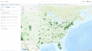
Example ArcGIS Online Map Showing US Population by County Example ArcGIS Online Map Showing US Population by County
Example ArcGIS Online Map Showing US Population by County
ArcGIS Online can be used to visualize data, analyze spatial patterns, and present materials in a professional-looking web application. We'll cover the basics of creating beautiful web maps, and how to share content to facilitate collaboration.
Example ArcGIS Online Map Showing US Population by County Example ArcGIS Online Map Showing US Population by County
Example ArcGIS Online Map Showing US Population by County

Explore Similar Events

  •  Loading Similar Events...

Back to Main Content